55-km integrated infrastructure study

The 55-km DRT Corridor - Engineering a New Frontier.

A continuous 1-km occupied crest, a 4-meter dam wall, and three specialized districts assembled as one engineered land-water platform.

55km

Corridor length

1km

Crest width

4m

Dam wall

Fig. 01 — Primary engineering parameters

Supplied aerial masterplan of the DRT dual-zone corridor with productive and industrial districts, MRT, divided superhighway, reinforced embankments, reservoir-edge facilities, and aquaculture areas
West · Productive land, industry, MRT, and stationsCenter · Reinforced embankments and divided superhighwayEast · Utilities, reservoir edge, and aquaculture areas

Masterplan index — select a district to view its structures and indicative capacity

Executive brief

Central Bulacan Multimodal Arterial Corridor & Dual-Zone Development

A concept-stage overview of the problem, the proposed intervention, and the three integrated roles the DRT Corridor is designed to perform.

In early August 2026, Central Luzon experienced severe and prolonged flooding as intense monsoon rains (Habagat) combined with successive typhoons. Large portions of Pampanga, Bulacan, and northern Metro Manila remained submerged well into September.

Hydrometeorological assessments point to a dominant source of this flooding: massive runoff originating from the Sierra Madre mountain range. Over a two-week period, moisture drawn from the Pacific Ocean produced an estimated 260 million cubic meters of rainfall across the highlands, particularly within Doña Remedios Trinidad (DRT), Bulacan, extending toward the boundaries of San Jose del Monte and Gapan, Nueva Ecija. This concentrated rainfall overwhelmed downstream basins and contributed significantly to the widespread inundation.

To address this recurring hazard, a multi-purpose flood-management and development project is proposed: a 1-kilometer-wide, 4-meter-high low-lying dam spanning DRT toward Gapan. Conceived as an integrated regional hub, the project is designed to function as three complementary systems in one continuous corridor.

01

Water Management Infrastructure

A flood-control barrier and freshwater reservoir to intercept and regulate Sierra Madre runoff.

02

Economic Development Zone

Allocated areas for data centers, aquaculture systems, and complementary industries.

03

Transit and Mobility Corridors

A new superhighway and an extended MRT-7 line connecting San Jose del Monte to Gapan, Nueva Ecija.

This combined infrastructure aims to mitigate flood risks while enabling long-term economic and transport development across Central Luzon. All figures, alignments, and capacities shown on this site are concept-stage and subject to detailed engineering, environmental review, and validation.

Corridor overview

A single crest, three 10-km operational zones

The zones occupy distinct portions of the full 55-km alignment. Select a segment to move directly to its complete district study.

0 km · West1020304055 km · East
25 km · corridor continuity
Western outletGround-level MRT and occupied crestEastern reservoir

Typical cross-section A—A

Land → Water

Land sideZone structures + ground-level MRT
Rock embankmentWest boundary

1-km occupied crest

6-lane highwayStructures + buffersWater-dependent zone
Rock embankmentEast boundary
ReservoirInlet + culvert
Continuous 4-meter dam wall beneath crest

Regional context

The central gateway between Metro Manila and Nueva Ecija

The 55-km DRT Corridor runs from San Jose del Monte, Bulacan to Gapan, Nueva Ecija along Bulacan's northern growth axis — linking Calumpit, Pulilan, and Baliwag as development nodes and positioning DRT to catalyze industrial, residential, and logistics expansion across the Bulacan–Nueva Ecija corridor.

Indicative map of the 55-km DRT Corridor from San Jose del Monte, Bulacan to Gapan, Nueva EcijaA regional diagram of Bulacan and southern Nueva Ecija showing the indicative DRT Corridor from San Jose del Monte through Doña Remedios Trinidad to Gapan, with Calumpit, Pulilan, and Baliwag as development nodes, NLEX, the Plaridel Bypass, the Angat River system, the Sierra Madre, Manila Bay, and Metro Manila.San Jose del MonteGapan, Nueva EcijaBaliwagPulilanCalumpitMetro ManilaManila BaySierra MadreAngat RiverNLEXPlaridel BypassDRT · Gateway hubIndicative 55-kmDRT CorridorN
Fig. 02 — Bulacan–Nueva Ecija regional placementConcept alignment · not for navigation

Zone programme

Three districts, one connected operating platform

Each 10-km zone follows the same land-to-water arrangement shown in the updated masterplan. Capacity ranges are concept-stage allowances for comparison, not final design commitments.

Zone 01 · KM 00–10 · 10-km segment

Data Centers / AI / Pax Silica
01
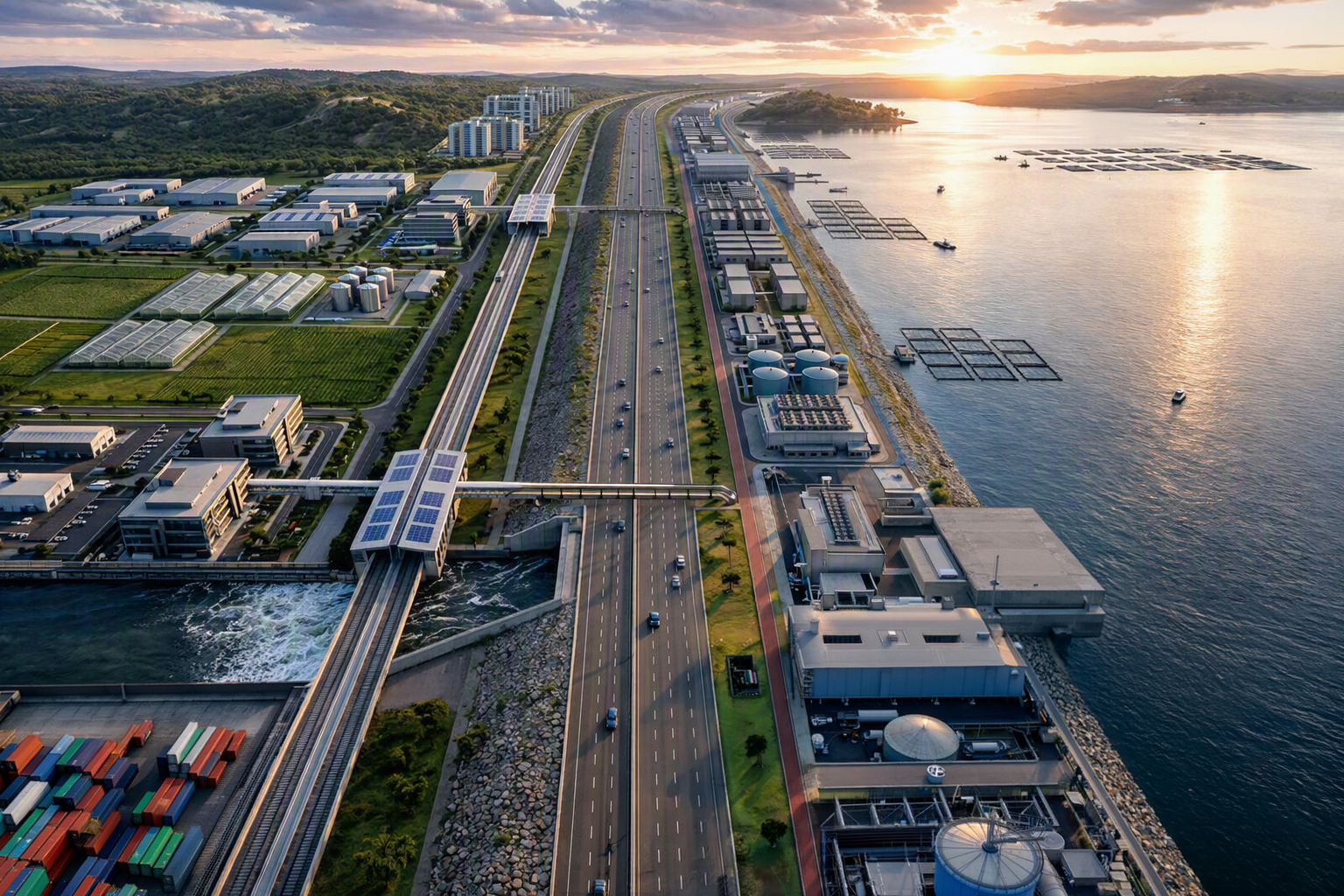
Western detail of the supplied DRT dual-zone masterplan showing buildings, productive land, MRT, and the multimodal corridor
Supplied masterplan reference · Zone 01Full view

Digital infrastructure at water's edge

The first 10-km district combines sovereign digital infrastructure with direct access to transport, utilities, and the western industrial locator zone.

200–400 MW

Indicative IT load

12–20

Modular data halls

60–120 ha

Secure campus area

Indicative concept capacity · subject to technical validation

Land side

  • Industrial locator zone
  • Ground-level MRT rail and stations
  • Western rock-reinforced embankment

Occupied crest

  • Three-lane-per-direction superhighway
  • Data halls and secure utility compounds
  • AI and Pax Silica offices
  • Landscaped operational buffers

Controlled east edge

  • Eastern rock-reinforced embankment
  • Controlled service inlet
  • Box-culvert connection
  • Open-water setback

Zone 02 · KM 10–20 · 10-km segment

Customs / Agricultural Silos / Aquaculture

02
Central detail of the supplied DRT dual-zone masterplan showing MRT stations, the divided highway, embankments, and logistics facilities
Supplied masterplan reference · Zone 02Full view

A productive gateway for food and trade

The second 10-km district links customs clearance and bulk agricultural storage to cold-chain logistics and food-processing operations on the land side and crest.

0.8–1.5 Mt/y

Trade throughput

400–700 kt

Dry-bulk storage

80–150 kt/y

Cold-chain handling

Indicative concept capacity · subject to technical validation

Land side

  • Bureau of Customs compound
  • Agricultural warehouses and silos
  • Ground-level MRT rail and stations

Occupied crest

  • Three-lane-per-direction superhighway
  • Inspection and logistics yards
  • Cold storage and processing buildings
  • Landscaped operational buffers

Controlled east edge

  • Eastern rock-reinforced embankment
  • Controlled service inlet
  • Box-culvert connection
  • Open-water setback

Zone 03 · KM 20–30 · 10-km segment

Seaport Bridge / Fuel Reserve / Cargo Airport

03
Eastern detail of the supplied DRT dual-zone masterplan showing fuel and utility facilities beside the reservoir and aquaculture areas
Supplied masterplan reference · Zone 03Full view

A multimodal eastern logistics frontier

The third 10-km district concentrates strategic fuel storage, bridge-linked freight movement, and air-cargo operations on one transport-connected platform.

0.8–1.5 Mt/y

Air-cargo handling

1.0–1.8 bn L

Fuel reserve

3.2–4.0 km

Runway length

Indicative concept capacity · subject to technical validation

Land side

  • Seaport bridge and freight trucks
  • Fuel and strategic reserve tanks
  • Bulk-cargo logistics yards
  • Ground-level MRT and stations

Occupied crest

  • Three-lane-per-direction superhighway
  • Two cargo runways
  • Control tower, hangars, and aprons
  • Airport service and sorting buildings

Controlled east edge

  • Eastern rock-reinforced embankment
  • Controlled service inlet
  • Box-culvert connection
  • Open-water setback

Western ecozone

A living buffer beside the corridor's land-side systems

The ecozone occupies the western landscape shown at the left of the masterplan, protecting the river outlet and separating habitat restoration from the MRT, embankment, and operational districts.

Habitat, flood passage, and public landscape

Native planting, riparian repair, bioswales, wildlife crossings, and maintenance tracks form a continuous ecological edge. No storage basin or offshore structure is proposed within the water body.

Locate on masterplan

1,500–2,500 ha

Indicative habitat restoration envelope

Indicative · subject to EIA

30–50 m

Typical planted separation at sensitive interfaces

Indicative · subject to EIA

100%

River-outlet passage kept unobstructed

Indicative · subject to EIA

3 layers

Riparian, woodland, and grassland planting

Indicative · subject to EIA

ECO-01

Protect

Retain a clear river outlet, stabilize banks, and preserve flood conveyance.

ECO-02

Reconnect

Use native planting and wildlife crossings to reconnect fragmented habitat.

ECO-03

Monitor

Track water quality, erosion, canopy establishment, and habitat performance.

Engineering systems

One crest, four systems in continuous alignment

The wall, crest, rail, and controlled water flow operate as a single infrastructural system across the full corridor.

Dam wall

4 meters below the crest · continuous for 55 km

SYS-01

Occupied crest

1 km wide · structures and landscape from edge to edge

SYS-02

Mobility spine

Ground-level MRT · stations · six-lane superhighway

SYS-03

Land–water flow

Western outlet · eastern culvert and inlet · reservoir

SYS-04

Land–water continuity

Infrastructure arranged by flow, access, and edge

Every zone repeats the same governing sequence while adapting its center and water-dependent edge to a different economic purpose.

01

Land side

Industry, freight access, MRT stations

02

Occupied crest

Highway, structures, utilities, landscape

03

Controlled edge

Rock reinforcement, wall, outlet and inlet

04

Reservoir

Water supply and water-dependent operations

Cost + timeline

A phased 15-year delivery program

Concept-level ranges align the corridor's civil, mobility, utility, ecological, and district packages. They establish an order of magnitude for planning—not a tender price or funding commitment.

Total capital range

₱2.9–5.1T

Approximately $51–89B

Indicative duration

2027–2042

15 years · overlapping packages

Opening strategy

Phased

Early systems and districts may open before full completion

Delivery sequence

Six overlapping phases

  1. Phase 012027–2029

    Validation + approvals

    Feasibility, surveys, environmental review, land strategy, reference design, procurement and financing structure.

    MilestoneInvestment decision
  2. Phase 022029–2032

    Enabling works

    Access, staging areas, utility diversions, river-outlet protection and early western ecozone restoration.

    MilestoneMain works notice
  3. Phase 032031–2037

    Core corridor formation

    Dam wall, engineered fill, western and eastern rock embankments, drainage, inlet and continuous crest formation.

    MilestoneContinuous crest
  4. Phase 042034–2039

    Mobility + utilities

    Ground-level MRT, stations, six-lane highway, substations, water, communications and district utility spines.

    MilestoneSystems energized
  5. Phase 052037–2041

    Zones 1–3 delivery

    Data district, customs and agro-logistics facilities, fuel reserve, cargo aviation and associated operational buildings.

    MilestoneDistrict handovers
  6. Phase 062041–2042

    Integration + opening

    Testing, safety certification, ecological monitoring baseline, operator readiness and phased public opening.

    MilestoneFull operations
20272029203120332035203720392042
Phase 01Validation + approvals
Phase 02Enabling works
Phase 03Core corridor formation
Phase 04Mobility + utilities
Phase 05Zones 1–3 delivery
Phase 06Integration + opening

Fig. 04 — Indicative program · sequencing subject to approvals and procurement strategy